And for a couple of years in the late 1910s, it seemed as if the people were right. Thousands of people poured into the Upper Cook Inlet. An August 1916 local census found 3,332 people living within city limits, with an estimated 6,000 total residents in the area. By February 1917, the number of residents within city limits had risen to 5,209. But railroad construction moved away from the area, and there was war and disease besides. The 1920 Census revealed only 1,856 residents in Anchorage proper, and the city would not surpass its 1917 peak until the early 1940s.
Government Hill
Government Hill residents sometimes describe their community as Anchorage’s first neighborhood. The AEC built a line of cottages on a bluff overlooking Ship Creek. Other settlers called it the “plateau” or the “plateau north of the flat,” rather unassuming names. Soon, it gained a new name:
Government Hill.
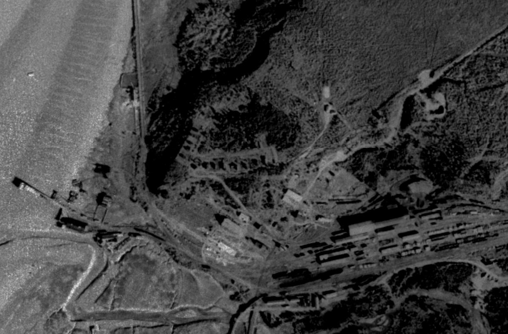
1939 - Aerial view of Government Hill
There are two possible origins for the new name. First, it was a literal appellation. There were government employees atop a bluff, thus a “government hill.” Second, it perhaps recalled a location in Panama. The Panama Canal opened in April 1914, and many of the surviving engineers and laborers involved there moved north for the newest megaproject, the construction of the Alaska Railroad. The Mears family was among those migrants. In Panama, there was a similar site called Government Hill, and when people arrived in Anchorage and saw something like it, the name was repeated. One or both origins could be true, as they reinforce each other.
Until 1940, Government Hill remained essentially that, those original homes plus a few scattered homesteads to the north and east. To the south of the townsite—modern downtown—was the park strip, first created as a firebreak between the city and the surrounding forest. In the late 1910s, it was home to Anchorage’s first red-light district. Through the 1920s and 1930s, a few homes lined the far side of the park strip, followed by a series of small farms and homesteads. That area was unoriginally referred to as the South Addition, just as the area directly east of the townsite was the East Addition. When annexed in the mid-1940s, they were the first expansion to the city limits, thus a literal “addition.”
Government Hill was also referred to as the North Addition, although there was some confusion over its legal status. As of 1946, no one, not even the residents or Anchorage officials, was sure whether Government Hill was actually within the city or not. Different agencies and departments gave different answers. The matter was settled on June 5, 1946, when the southern portion of the neighborhood was formally declared a part of the city. The rest of Government Hill was annexed in 1960.
Mountain View, Spenard, and Fairview
The city finally began to boom again during the 1940s. In 1939, Anchorage was selected as home to a new army base, Fort Richardson. Construction began the following year, and the first troops arrived on June 27, 1940. The population skyrocketed as families and construction workers flooded into town. From around 4,000 residents in 1940, there were 32,000 people in the greater Anchorage area in 1950.
But a town built for 4,000 people cannot adequately house 32,000 people. Of that latter amount, only around 11,000 lived within the city. The rest were forced to build new homes outside the city, in neighborhoods that soon formed their own identities: Mountain View, Eastchester, and Spenard.
Mountain View was the first of these communities to develop. In 1940, homesteader Norman Lange subdivided his land and began selling off lots. He called his subdivision Mountain View, which became the name for the wider neighborhood. Many of the streets there are named for early residents, such as Bragaw for territorial legislator and photographer Robert Bragaw, and Bliss Street for contractor Harry Bliss. Klevin Street is named after Norwegian immigrant Nels Kleven; The current street name is misspelled from its origin.
Commercial development in Spenard dates back to its namesake, Canadian entrepreneur Joe Spenard. In 1916, he built an illegal road to an illegal club at Lake Spenard on land he did not own. That roadhouse burned down in 1917, and he left town soon after, but the Spenard name stuck. From then into 1946, there was minimal development south of Chester Creek, what is now modern-day Spenard. There were homesteads, a new roadhouse at the lake, and a few homes on Fireweed Lane, which, while outside the official city limits, was sort of an unofficial end to the city, with the City of Anchorage even running power lines out there in the 1930s. Modern development of the Spenard area began in 1946, with the subdivision and construction at the corner of Fireweed and Spenard Road.
Eastchester lay to the immediate southeast of downtown. Due to pervasive housing discrimination, Black individuals were barred from living in most of the Anchorage area. Eastchester Flats was one of the only unrestricted districts, in the section of Eastchester between 15th Avenue and Chester Creek, around where the Anchorage Senior Activity Center is today. Commonly referred to as the Flats, this resultant Black community was driven out by urban renewal in the 1960s as the area was razed for new, denser housing.
While forced by necessity to live outside Anchorage proper, the residents of these newer communities could hardly afford to wait for existing services to extend to their new homes. The solution was public utility districts (PUDs), which were created by the territorial legislature in 1936, in legislation that successfully predicted the rise of extensive residential developments outside existing city limits and service areas. PUDs were authorized to collect taxes and fees, albeit with strict limits. They could also offer bonds to provide the most basic public services, such as water, electricity, garbage collection, road construction, dust control, grading, signage, parks, and traffic lights. In essence, they were simplified civic governments, lacking a mayor or council but with the ability to respond to resident needs. Spenard formed the first local PUD in May 1948. Eastchester and Mountain View followed in August 1948 and November 1949, respectively.
Anchorage officials had a different perspective on PUDs and the outlying neighborhoods. As they saw it, the city provided many services and other benefits that were enjoyed by the wider community but which were paid for by only a fraction of the possible tax base. In response, they initiated an aggressive campaign of annexation, which began with Mountain View in two stages across 1954. The Flats were also annexed that year, and the remaining Eastchester residents chose to rename their community Fairview, as they no longer had a connection to Chester Creek. Realtor Greg Merims, freshly arrived from California, submitted the winning Fairview entry in a renaming contest sponsored by the PUD.
Public sentiment in the remaining independent communities, primarily Fairview and Spenard, subsequently hardened against annexation. A significant portion of the community enjoyed and prospered from the lack of taxes, ordinances, and police outside city limits. The only law enforcement came from the inconsistent presence of what would become the State Troopers. In 1954, U.S. District Court Judge George Folta noted that much of the opposition to annexation “stems from the operators of illicit and disreputable places who resist annexation in order to avoid police regulation.”
Elections in 1959, open to a broader swath of residents than previous annexation votes, expanded the city borders, including small portions of Fairview and the section of Spenard between Northern Lights Boulevard and Chester Creek. At this point, the remaining independent Fairview was surrounded by Anchorage, an island without visible boundaries.
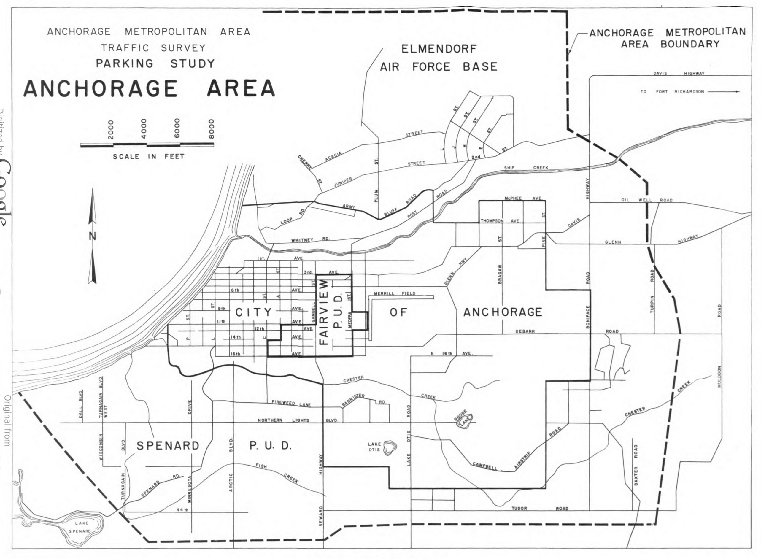
1959 - Map of the Anchorage Metro Area
Local Boundary Commission
After Alaska was admitted as a state on January 3, 1959, the new state legislature passed the State Organization Act, which established the basic framework of the state government and infrastructure. The Act also established the Local Boundary Commission as part of the governor’s office. The Commission was invested with the power to make final decisions on city borders regardless of election outcomes.
On February 3, 1960, the Local Boundary Commission authorized the annexation of the rest of Fairview into Anchorage. Debate in the State Legislature on the topic was lively and divisive, with one Senator wondering, “There must be some way this area can solve its problems without twenty people here acting for them.” Eventually, the State House of Representatives disapproved of the Commission’s decision, while the State Senate approved it. With the two houses divided, the Commission’s ruling held, and the Anchorage City Council officially annexed Fairview into the city on March 22, 1960, though legal challenges followed, including an unsuccessful appeal all the way to the United States Supreme Court.
By 1963, the Anchorage bowl was broadly divided by Northern Lights Boulevard. Those same legislators, weary of constituent complaints, passed the Mandatory Borough Act, which prompted the unincorporated developments south of Northern Lights to form the Greater Anchorage Area Borough (GAAB) in 1964, still centered around Spenard. From there, the GAAB and City of Anchorage acrimoniously divided governance in the Anchorage bowl until the merger into the modern Municipality of Anchorage in 1975.